Layers · Angular, React and OpenLayers
Pan and zoom a static image
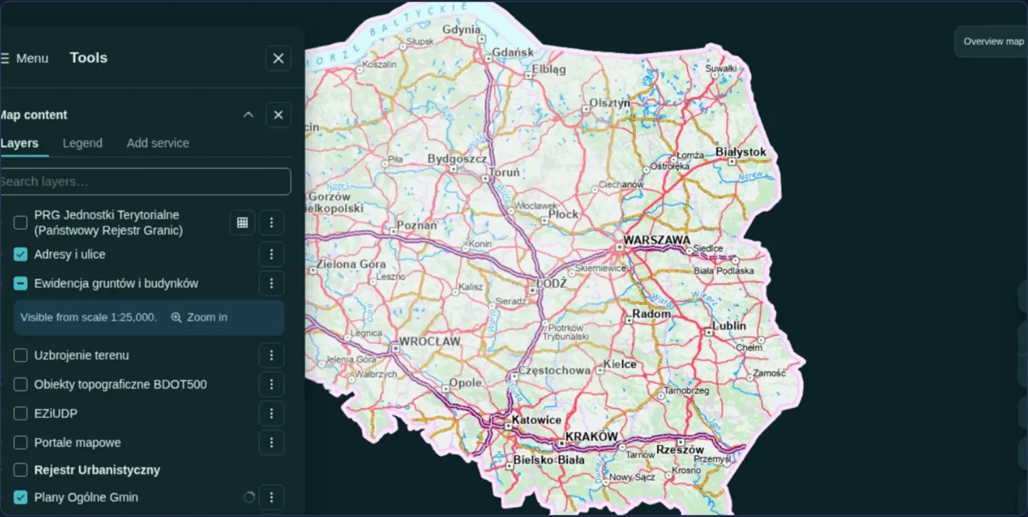
Display non-geographic floor plans, diagrams or screenshots in OpenLayers using a custom pixel-based Projection and an ImageStatic source.
What this example shows
An application screenshot (1280 × 800 pixels) mounts inside OpenLayers in a projection of its own, so its coordinates count image pixels instead of Earth longitude and latitude.
When you need it
Building floor plans, stadium seating charts, engineering schematics, historical manuscript scans and industrial P&ID diagrams have no geographic CRS yet benefit enormously from OpenLayers’ pan, zoom and vector-annotation tools.
Defining a custom pixel projection lets you overlay interactive vector pins, measurement polygons and HTML popups in straightforward [x, y] image pixel coordinates.
The code
The example uses cc-openlayers, my Angular component library for OpenLayers: each aol-… element creates the OpenLayers object it names, updates it from its inputs and disposes of it with the component.
image-static.tsimport { ChangeDetectionStrategy, Component } from '@angular/core';
import type { Extent } from 'ol/extent';
import Projection from 'ol/proj/Projection';
import { LayerImageComponent, MapComponent, SourceImageStaticComponent, ViewComponent } from 'cc-openlayers';
/** One image, a screenshot of GeoAtlas, as a map in a pixel projection of its own: panned and zoomed like any map. */
@Component({
selector: 'app-image-static',
imports: [LayerImageComponent, MapComponent, SourceImageStaticComponent, ViewComponent],
changeDetection: ChangeDetectionStrategy.OnPush,
template: `
<aol-map height="480px">
<aol-view [projection]="projection" [zoom]="2" [center]="[640, 400]" />
<aol-layer-image [extent]="extent">
<aol-source-imagestatic url="assets/geoatlas.webp" [projection]="projection" [imageExtent]="extent" />
</aol-layer-image>
</aol-map>
`,
})
export class ImageStatic {
/** The image's size in pixels: its coordinates run from the lower left corner. */
protected readonly extent: Extent = [0, 0, 1280, 800];
protected readonly projection = new Projection({ code: 'geoatlas-image', units: 'pixels', extent: this.extent });
} The React version uses the library's React adapter, cc-openlayers/react: each component creates the OpenLayers object it names when it mounts, updates it from its props and disposes of it when it unmounts.
image-static.react.tsximport type { Extent } from 'ol/extent';
import Projection from 'ol/proj/Projection';
import { ImageLayer, ImageStaticSource, Map, View } from 'cc-openlayers/react';
/** The image's size in pixels: its coordinates run from the lower left corner. */
const extent: Extent = [0, 0, 1280, 800];
const projection = new Projection({ code: 'geoatlas-image', units: 'pixels', extent });
/** One image, a screenshot of GeoAtlas, as a map in a pixel projection of its own: panned and zoomed like any map. */
export function ImageStatic() {
return (
<Map height="480px">
<View projection={projection} zoom={2} center={[640, 400]} />
<ImageLayer extent={extent}>
<ImageStaticSource url="assets/geoatlas.webp" projection={projection} imageExtent={extent} />
</ImageLayer>
</Map>
);
}How the React version works
A GeoAtlas screenshot is a map in a pixel projection (1280 × 800): it pans and zooms like any map.
What both versions share
OpenLayers renders the map and handles the interactions; the cc-openlayers/core layer gives both adapters the same view binding (MapViewBinding) and the same conversion of coordinates from EPSG:4326 to the map's projection. The geoatlas-image projection is created once, when the module loads.
From Angular to React
| Angular | React |
|---|---|
<aol-layer-image> with <aol-source-imagestatic> | <ImageLayer> with <ImageStaticSource> |
<aol-view [projection] [center]> | <View projection={projection} center={[640, 400]} /> |
Who creates, updates and disposes
Map creates the ol/Map in useLayoutEffect and disposes of it on unmount; each layer, source and interaction component adds its object to the parent it gets from context and removes it in its effect's cleanup, as ngOnDestroy does in Angular.
Architecture and OpenLayers mechanics
Instead of default Spherical Mercator, the component instantiates an OpenLayers Projection configured with units: 'pixels' and an extent matching the bitmap’s dimensions ([0, 0, 1280, 800], measured from the lower-left origin).
Both aol-view and aol-source-imagestatic (imageExtent) reference that exact pixel projection so view centre coordinates, zoom resolutions and any vector overlays map directly to image pixels.
How it works
- A custom OpenLayers
Projectionwithunits: 'pixels'and [0, 0, width, height] bounds replaces geographic coordinates. aol-source-imagestaticstretches the single bitmap acrossimageExtent(1280 × 800 pixels anchored at the bottom-left corner).- Sharing the pixel projection on the view expresses camera centre and resolution directly in image pixels.
Pitfalls
- Always match
imageExtentaspect ratio exactly to the bitmap’s natural pixel dimensions (naturalWidth × naturalHeight), otherwise OpenLayers stretches or squashes the drawing. - Browsers decode an
ImageStaticfile into memory all at once: for scans larger than ~4000 × 4000 pixels, slice the artwork into a Zoomify or IIIF tile pyramid instead so mobile GPUs do not hit texture limits.
Related examples
The same feature in the OpenLayers examples .
Background: state and lifecycle of maps in Angular with OpenLayers, which the components of cc-openlayers take care of.