Vector data · Angular, React and OpenLayers
Use a MapboxVectorLayer with a local style
Mount a standalone MapboxVectorLayer from a local Mapbox GL v8 style URL in OpenLayers to render municipality vector tiles alongside layers.
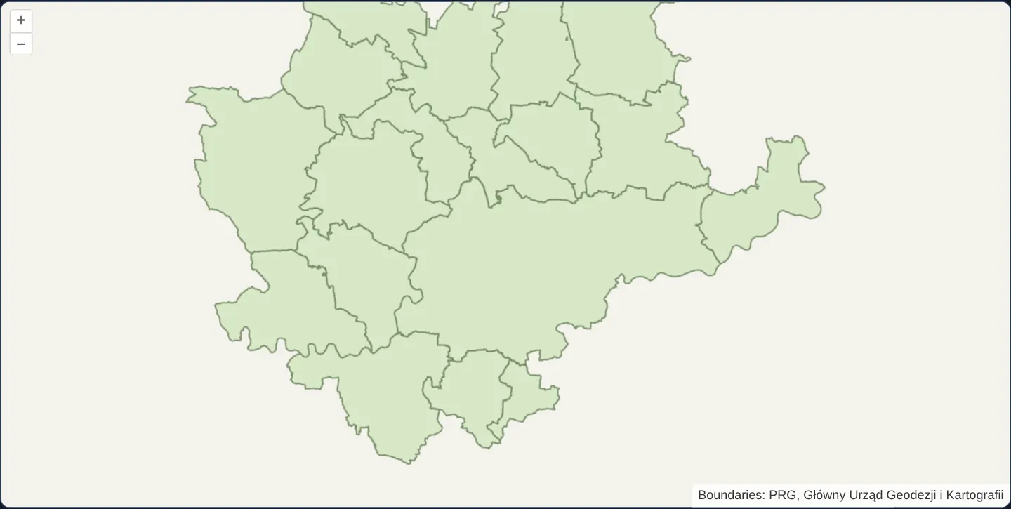
What this example shows
PRG municipal boundaries around Kraków render through ol-mapbox-style’s dedicated MapboxVectorLayer class pointed at a local GL v8 style URL—behaving as a single composable layer inside an Angular or React OpenLayers map.
When you need it
Unlike standalone basemap viewers where a Mapbox GL document owns the entire map, enterprise GIS apps usually manage their own OpenLayers View, controls and thematic WMS/GeoJSON layers—needing a GL-styled vector tileset to participate as just one layer in the stack.
MapboxVectorLayer encapsulates source creation and GL v8 styling inside a single Layer instance whose opacity, visibility and z-index your application controls like any other OpenLayers layer.
The code
The example uses cc-openlayers, my Angular component library for OpenLayers: each aol-… element creates the OpenLayers object it names, updates it from its inputs and disposes of it with the component.
mapbox-vector-layer.html<aol-map height="480px" ariaLabel="PRG municipality vector layer around Kraków">
<aol-interaction-default />
<aol-control-defaults [attributionOptions]="attributionOptions" />
<aol-view projection="EPSG:3857" [zoom]="10" [minZoom]="0" [maxZoom]="maxZoom">
<aol-coordinate [x]="19.9368" [y]="50.0614" srid="EPSG:4326" />
</aol-view>
</aol-map>
@if (styleError()) {
<p role="status">The local map style could not be loaded.</p>
}mapbox-vector-layer.scss:host {
display: block;
}mapbox-vector-layer.tsimport { AfterViewInit, ChangeDetectionStrategy, Component, OnDestroy, signal, viewChild } from '@angular/core';
import {
CoordinateComponent,
DefaultControlComponent,
DefaultInteractionComponent,
MapComponent,
ViewComponent,
} from 'cc-openlayers';
import { municipalityAttributionOptions, ownMunicipalityVectorLayer } from '../mapbox-style/mapbox-style.shared';
import { municipalityMaxZoom } from '../canvas-tiles-tms/canvas-tiles-tms.shared';
/** Uses ol-mapbox-style's MapboxVectorLayer with the local finite PRG source. */
@Component({
selector: 'app-mapbox-vector-layer',
imports: [CoordinateComponent, DefaultControlComponent, DefaultInteractionComponent, MapComponent, ViewComponent],
changeDetection: ChangeDetectionStrategy.OnPush,
templateUrl: './mapbox-vector-layer.html',
styleUrl: './mapbox-vector-layer.scss',
})
export class MapboxVectorLayerExample implements AfterViewInit, OnDestroy {
protected readonly attributionOptions = municipalityAttributionOptions;
protected readonly maxZoom = municipalityMaxZoom;
protected readonly styleError = signal(false);
private readonly map = viewChild.required(MapComponent);
private releaseLayer?: () => void;
ngAfterViewInit(): void {
this.releaseLayer = ownMunicipalityVectorLayer(this.map().instance, () => this.styleError.set(true));
}
ngOnDestroy(): void {
this.releaseLayer?.();
}
} The React version uses the library's React adapter, cc-openlayers/react: each component creates the OpenLayers object it names when it mounts, updates it from its props and disposes of it when it unmounts.
mapbox-vector-layer.react.tsximport { useCallback, useEffect, useState } from 'react';
import { Coordinate, DefaultControls, DefaultInteractions, Map, useMap, View } from 'cc-openlayers/react';
import { municipalityAttributionOptions, ownMunicipalityVectorLayer } from '../mapbox-style/mapbox-style.shared';
import { municipalityMaxZoom } from '../canvas-tiles-tms/canvas-tiles-tms.shared';
function AddLocalMapboxVectorLayer({ onError }: { onError: () => void }) {
const map = useMap();
useEffect(() => ownMunicipalityVectorLayer(map, onError), [map, onError]);
return null;
}
/** Uses ol-mapbox-style's MapboxVectorLayer with the local finite PRG source. */
export function MapboxVectorLayerReact() {
const [styleError, setStyleError] = useState(false);
const reportStyleError = useCallback(() => setStyleError(true), []);
return (
<>
<Map height="480px" ariaLabel="PRG municipality vector layer around Kraków">
<DefaultInteractions />
<DefaultControls attributionOptions={municipalityAttributionOptions} />
<View projection="EPSG:3857" zoom={10} minZoom={0} maxZoom={municipalityMaxZoom}>
<Coordinate x={19.9368} y={50.0614} srid="EPSG:4326" />
</View>
<AddLocalMapboxVectorLayer onError={reportStyleError} />
</Map>
{styleError ? <p role="status">The local map style could not be loaded.</p> : null}
</>
);
}Architecture and OpenLayers mechanics
Instantiating MapboxVectorLayer from ol-mapbox-style with a local style URL automatically reads the JSON style document, builds its internal vector-tile source targeting the local TMS 512-pixel PRG municipality pyramid, and renders the declared municipalities source layer while preserving required data attributions.
How it works
- MapboxVectorLayer from ol-mapbox-style encapsulates both vector-tile source setup and GL v8 styling inside one composable OpenLayers layer.
- Pointing the style URL at a local JSON asset requires no cloud API access token.
- The style document references the municipalities MVT source layer and retains GUGiK PRG attribution metadata.
Pitfalls
- Only proprietary mapbox:// protocol URLs require a Mapbox access token; standard relative or HTTPS style URLs work keyless against self-hosted tiles.
- Ensure the style document’s tile URL scheme (such as south-origin TMS {-y} vs north-origin {y}) matches the served MVT files.
Related examples
The same feature in the OpenLayers examples .
Background: state and lifecycle of maps in Angular with OpenLayers, which the components of cc-openlayers take care of.