Vector data · Angular, React and OpenLayers
Kraków districts from TopoJSON
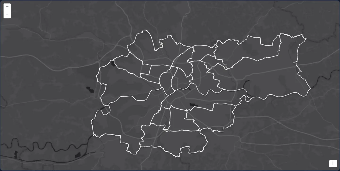
Render Kraków’s 18 administrative districts from a compact shared-arc TopoJSON topology over Esri Dark Gray using non-overlapping flat styles.
What this example shows
All eighteen municipal districts of Kraków appear outlined in crisp white over Esri’s World Dark Gray basemap—reconstructed in the browser from a compact TopoJSON file where adjacent districts share every common border arc exactly once.
When you need it
Administrative subdivisions, electoral precincts, postal zones and statistical census tracts share nearly every interior boundary edge with an immediate neighbour.
Encoding shared arcs once in TopoJSON slashes network payload size compared to GeoJSON and guarantees topological consistency with zero slivers or gaps along district seams.
The code
The example uses cc-openlayers, my Angular component library for OpenLayers: each aol-… element creates the OpenLayers object it names, updates it from its inputs and disposes of it with the component.
topojson.tsimport { ChangeDetectionStrategy, Component } from '@angular/core';
import TopoJSON from 'ol/format/TopoJSON';
import type { FlatStyle } from 'ol/style/flat';
import {
CoordinateComponent,
DefaultControlComponent,
DefaultInteractionComponent,
LayerTileComponent,
LayerVectorComponent,
MapComponent,
SourceImageTileComponent,
SourceVectorComponent,
ViewComponent,
} from 'cc-openlayers';
/**
* The eighteen districts of Kraków from a TopoJSON topology, in which each border between two districts is stored
* once as an arc both use, drawn over Esri's dark grey canvas.
*/
@Component({
selector: 'app-topojson',
imports: [
CoordinateComponent,
DefaultControlComponent,
DefaultInteractionComponent,
LayerTileComponent,
LayerVectorComponent,
MapComponent,
SourceImageTileComponent,
SourceVectorComponent,
ViewComponent,
],
changeDetection: ChangeDetectionStrategy.OnPush,
template: `
<aol-map height="480px">
<aol-interaction-default />
<aol-control-defaults />
<aol-view [zoom]="11">
<aol-coordinate [x]="19.945" [y]="50.057" srid="EPSG:4326" />
</aol-view>
<aol-layer-tile>
<aol-source-imagetile
url="https://server.arcgisonline.com/ArcGIS/rest/services/Canvas/World_Dark_Gray_Base/MapServer/tile/{z}/{y}/{x}"
[maxZoom]="16"
attributions="Tiles © Esri — Esri, HERE, Garmin, © OpenStreetMap contributors, and the GIS user community"
/>
</aol-layer-tile>
<aol-layer-vector [style]="style">
<aol-source-vector
url="assets/krakow/districts.topojson"
[format]="format"
[overlaps]="false"
attributions='Districts © <a href="https://www.openstreetmap.org/copyright" target="_blank">OpenStreetMap</a> contributors'
/>
</aol-layer-vector>
</aol-map>
`,
})
export class Topojson {
/** Only the topology's districts; a topology may hold more objects, such as their union. */
protected readonly format = new TopoJSON({ layers: ['districts'] });
protected readonly style: FlatStyle = { 'stroke-color': '#ffffff', 'stroke-width': 1.5 };
} The React version uses the library's React adapter, cc-openlayers/react: each component creates the OpenLayers object it names when it mounts, updates it from its props and disposes of it when it unmounts.
topojson.react.tsximport TopoJSON from 'ol/format/TopoJSON.js';
import type { FlatStyle } from 'ol/style/flat.js';
import {
Coordinate,
DefaultControls,
DefaultInteractions,
ImageTileSource,
Map,
TileLayer,
VectorLayer,
VectorSource,
View,
} from 'cc-openlayers/react';
/** Only the topology's districts; a topology may hold more objects, such as their union. */
const format = new TopoJSON({ layers: ['districts'] });
const style: FlatStyle = { 'stroke-color': '#ffffff', 'stroke-width': 1.5 };
/**
* The eighteen districts of Kraków from a TopoJSON topology, in which each border between two districts is stored
* once as an arc both use, drawn over Esri's dark grey canvas.
*/
export function Topojson() {
return (
<Map height="480px">
<DefaultInteractions />
<DefaultControls />
<View zoom={11}>
<Coordinate x={19.945} y={50.057} srid="EPSG:4326" />
</View>
<TileLayer>
<ImageTileSource
url="https://server.arcgisonline.com/ArcGIS/rest/services/Canvas/World_Dark_Gray_Base/MapServer/tile/{z}/{y}/{x}"
maxZoom={16}
attributions="Tiles © Esri — Esri, HERE, Garmin, © OpenStreetMap contributors, and the GIS user community"
/>
</TileLayer>
<VectorLayer style={style}>
<VectorSource
url="assets/krakow/districts.topojson"
format={format}
overlaps={false}
attributions='Districts © <a href="https://www.openstreetmap.org/copyright" target="_blank">OpenStreetMap</a> contributors'
/>
</VectorLayer>
</Map>
);
}How the React version works
Kraków's eighteen districts from a TopoJSON topology, which stores each border once, over Esri's dark base map.
What both versions share
OpenLayers renders the map and handles the interactions; the cc-openlayers/core layer gives both adapters the same view binding (MapViewBinding) and the same conversion of coordinates from EPSG:4326 to the map's projection.
From Angular to React
| Angular | React |
|---|---|
<aol-layer-vector> with <aol-source-vector [url] [format]> | <VectorLayer> with <VectorSource url format>; the format is a module constant |
the layer's [style] | the layer's style: a function or a flat style, constant in the module |
Who creates, updates and disposes
Map creates the ol/Map in useLayoutEffect and disposes of it on unmount; each layer, source and interaction component adds its object to the parent it gets from context and removes it in its effect's cleanup, as ngOnDestroy does in Angular.
Architecture and OpenLayers mechanics
OpenLayers’ TopoJSON format decodes shared arcs from geographic degrees into projected polygon rings, filtering the file via layers: ['districts'] so only the districts topology object is extracted. Setting [overlaps]="false" on the vector source informs OpenLayers’ canvas renderer that polygons partition space cleanly without overlapping interiors—enabling faster batched stroke and fill passes using a concise flat style (stroke-color and stroke-width).
How it works
TopoJSONreconstructs each district polygon from shared arc indices and transforms coordinates into the view projection.layers: ['districts']extracts solely thedistrictstopology collection when a file bundles multiple named layers.[overlaps]="false"lets the vector renderer batch drawing passes safely for mutually exclusive administrative polygons.- A flat style with
stroke-colorandstroke-widthdraws crisp white borders while leaving the dark basemap visible inside.
Pitfalls
- Topological deduplication applies to wire transfer size only: once parsed into OpenLayers memory, each district becomes a standalone Polygon feature whose shared boundary edges are stored and stroked per polygon.
- Omitting the
layersfilter imports every named geometry collection inside the TopoJSON file—potentially stacking outer city outlines on top of interior districts.
Related examples
The same feature in the OpenLayers examples .
Background: state and lifecycle of maps in Angular with OpenLayers, which the components of cc-openlayers take care of.