Vector data · Angular, React and OpenLayers
The world's time zones from KML
Style world time-zone polygons from KML in OpenLayers by proximity to local solar noon using silent feature property updates and hover labels.
What this example shows
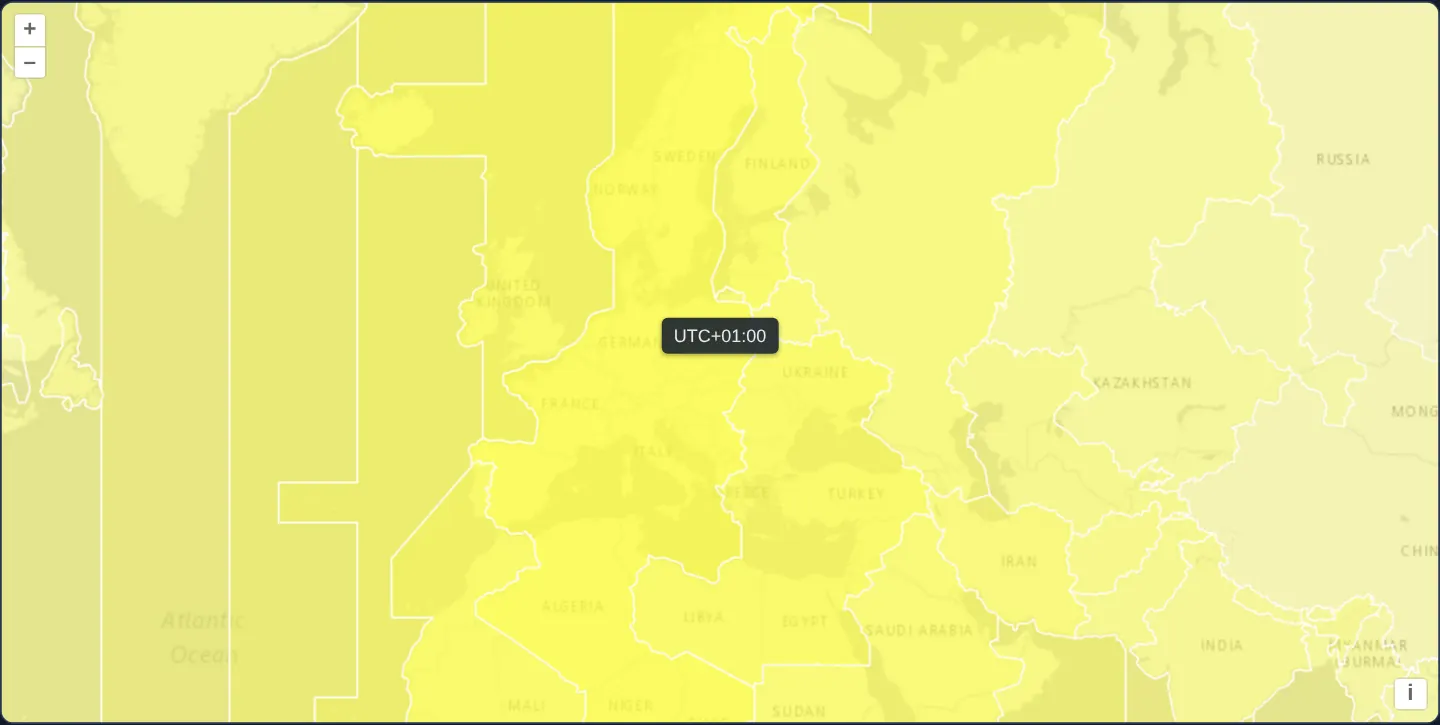
Across a global light-grey map centred on Europe, all 119 world time zones (121 polygons, since two offsets hold a MultiGeometry) from a KML dataset glow in warm yellow whose opacity peaks at 0.75 in whichever zone is currently experiencing local noon and fades smoothly to transparent toward local midnight, paired with a live UTC-offset tooltip under the pointer.
When you need it
Global operations centres, distributed-team directories, follow-the-sun support dashboards and aviation schedulers benefit from visualising active daytime and business hours dynamically across time-zone polygons.
Computing fill opacity dynamically inside a style function turns a static boundary file into a live global clock without modifying server data.
The code
The example uses cc-openlayers, my Angular component library for OpenLayers: each aol-… element creates the OpenLayers object it names, updates it from its inputs and disposes of it with the component.
kml-timezones.tsimport { afterNextRender, ChangeDetectionStrategy, Component, signal, viewChild } from '@angular/core';
import type { Coordinate } from 'ol/coordinate';
import type { FeatureLike } from 'ol/Feature';
import KML from 'ol/format/KML';
import type MapBrowserEvent from 'ol/MapBrowserEvent';
import type { VectorSourceEvent } from 'ol/source/Vector';
import Fill from 'ol/style/Fill';
import Stroke from 'ol/style/Stroke';
import Style from 'ol/style/Style';
import {
ContentComponent,
CoordinateComponent,
DefaultControlComponent,
DefaultInteractionComponent,
LayerTileComponent,
LayerVectorComponent,
MapComponent,
OverlayComponent,
SourceImageTileComponent,
SourceVectorComponent,
ViewComponent,
} from 'cc-openlayers';
/*
* Compute the style of the feature. Here we want the opacity of polygons to
* be based on the offset from local noon. For example, a timezone where it is
* currently noon would have an opacity of 0.75. And a timezone where it is
* currently midnight would have an opacity of 0. This doesn't account for
* daylight savings, so don't use it to plan your vacation.
*/
const styleFunction = function (feature: FeatureLike) {
const tzOffset = feature.get('tz-offset');
const local = new Date();
local.setTime(local.getTime() + (local.getTimezoneOffset() + (tzOffset || 0)) * 60000);
// offset from local noon (in hours)
let delta = Math.abs(12 - (local.getHours() + local.getMinutes() / 60));
if (delta > 12) {
delta = 24 - delta;
}
const opacity = 0.75 * (1 - delta / 12);
return new Style({
fill: new Fill({
color: [0xff, 0xff, 0x33, opacity],
}),
stroke: new Stroke({
color: '#ffffff',
}),
});
};
/**
* @param name e.g. UTC-08:30
* @return The offset from UTC in minutes
*/
function parseOffsetFromUtc(name: string): number | null {
const match = name.match(/([+-]?)(\d{2}):(\d{2})$/);
if (!match) {
return null;
}
const sign = match[1] === '-' ? -1 : 1;
const hours = Number(match[2]);
const minutes = Number(match[3]);
return sign * (60 * hours + minutes);
}
/**
* The world's time zones read from a KML file and filled yellow, the more opaque the nearer the zone is to local noon,
* seen from Kraków in the middle of its own zone. A tooltip at the pointer names the zone under it.
*/
@Component({
selector: 'app-kml-timezones',
imports: [
ContentComponent,
CoordinateComponent,
DefaultControlComponent,
DefaultInteractionComponent,
LayerTileComponent,
LayerVectorComponent,
MapComponent,
OverlayComponent,
SourceImageTileComponent,
SourceVectorComponent,
ViewComponent,
],
changeDetection: ChangeDetectionStrategy.OnPush,
template: `
<aol-map height="480px" (pointerMove)="move($event)" (olClick)="displayFeatureInfo($event)" (pointerleave)="hide()">
<aol-interaction-default />
<aol-control-defaults />
<aol-view [zoom]="3">
<aol-coordinate [x]="19.9373" [y]="50.0617" srid="EPSG:4326" />
</aol-view>
<aol-layer-tile>
<aol-source-imagetile
url="https://server.arcgisonline.com/ArcGIS/rest/services/Canvas/World_Light_Gray_Base/MapServer/tile/{z}/{y}/{x}"
[maxZoom]="16"
attributions="Tiles © Esri — Esri, HERE, Garmin, © OpenStreetMap contributors, and the GIS user community"
/>
</aol-layer-tile>
<aol-layer-vector [style]="style">
<aol-source-vector
url="assets/world/time-zones.kml"
[format]="format"
attributions="Time zones: Natural Earth"
/>
</aol-layer-vector>
<aol-overlay positioning="bottom-center" [offset]="[0, -5]" [stopEvent]="false">
<aol-coordinate [x]="position()[0]" [y]="position()[1]" />
<aol-content>
@if (info(); as name) {
<span class="example-label">{{ name }}</span>
}
</aol-content>
</aol-overlay>
</aol-map>
`,
})
export class KmlTimezones {
/** The name of the zone under the pointer, shown in the tooltip. */
readonly info = signal('');
readonly position = signal<Coordinate>([0, 0]);
protected readonly style = styleFunction;
protected readonly format = new KML({
extractStyles: false,
});
private readonly map = viewChild.required(MapComponent);
private readonly source = viewChild.required(SourceVectorComponent);
constructor() {
afterNextRender(() =>
this.source().instance.on('featuresloadend', function (evt: VectorSourceEvent) {
evt.features?.forEach(function (feature) {
const tzOffset = parseOffsetFromUtc(feature.get('name'));
feature.set('tz-offset', tzOffset, true);
});
})
);
}
protected move(event: MapBrowserEvent): void {
if (event.dragging) {
this.hide();
return;
}
this.displayFeatureInfo(event);
}
protected displayFeatureInfo(event: MapBrowserEvent): void {
const target = event.originalEvent.target as Element | null;
const feature = target?.closest('.ol-control')
? undefined
: this.map().instance.forEachFeatureAtPixel(event.pixel, function (feature) {
return feature;
});
if (!feature) {
this.hide();
return;
}
this.position.set(event.coordinate);
this.info.set(feature.get('name'));
}
protected hide(): void {
this.info.set('');
}
} The React version uses the library's React adapter, cc-openlayers/react: each component creates the OpenLayers object it names when it mounts, updates it from its props and disposes of it when it unmounts.
kml-timezones.react.tsximport { useRef, useState } from 'react';
import type { Coordinate as OLCoordinate } from 'ol/coordinate.js';
import type { FeatureLike } from 'ol/Feature.js';
import KML from 'ol/format/KML.js';
import type OLMap from 'ol/Map.js';
import type MapBrowserEvent from 'ol/MapBrowserEvent.js';
import type { VectorSourceEvent } from 'ol/source/Vector.js';
import Fill from 'ol/style/Fill.js';
import Stroke from 'ol/style/Stroke.js';
import Style from 'ol/style/Style.js';
import {
Coordinate,
DefaultControls,
DefaultInteractions,
ImageTileSource,
Map,
Overlay,
TileLayer,
VectorLayer,
VectorSource,
View,
} from 'cc-openlayers/react';
/*
* Compute the style of the feature. Here we want the opacity of polygons to
* be based on the offset from local noon. For example, a timezone where it is
* currently noon would have an opacity of 0.75. And a timezone where it is
* currently midnight would have an opacity of 0. This doesn't account for
* daylight savings, so don't use it to plan your vacation.
*/
const styleFunction = function (feature: FeatureLike) {
const tzOffset = feature.get('tz-offset');
const local = new Date();
local.setTime(local.getTime() + (local.getTimezoneOffset() + (tzOffset || 0)) * 60000);
// offset from local noon (in hours)
let delta = Math.abs(12 - (local.getHours() + local.getMinutes() / 60));
if (delta > 12) {
delta = 24 - delta;
}
const opacity = 0.75 * (1 - delta / 12);
return new Style({
fill: new Fill({
color: [0xff, 0xff, 0x33, opacity],
}),
stroke: new Stroke({
color: '#ffffff',
}),
});
};
/**
* @param name e.g. UTC-08:30
* @return The offset from UTC in minutes
*/
function parseOffsetFromUtc(name: string): number | null {
const match = name.match(/([+-]?)(\d{2}):(\d{2})$/);
if (!match) {
return null;
}
const sign = match[1] === '-' ? -1 : 1;
const hours = Number(match[2]);
const minutes = Number(match[3]);
return sign * (60 * hours + minutes);
}
const format = new KML({
extractStyles: false,
});
const OFFSET = [0, -5];
const readOffsets = (evt: VectorSourceEvent) => {
evt.features?.forEach(function (feature) {
const tzOffset = parseOffsetFromUtc(feature.get('name'));
feature.set('tz-offset', tzOffset, true);
});
};
/**
* The world's time zones read from a KML file and filled yellow, the more opaque the nearer the zone is to local noon,
* seen from Kraków in the middle of its own zone. A tooltip at the pointer names the zone under it.
*/
export function KmlTimezones() {
/** The name of the zone under the pointer, shown in the tooltip. */
const [info, setInfo] = useState('');
const [position, setPosition] = useState<OLCoordinate>([0, 0]);
const map = useRef<OLMap>(null);
const hide = () => setInfo('');
const move = (event: MapBrowserEvent) => {
if (event.dragging) {
hide();
return;
}
displayFeatureInfo(event);
};
const displayFeatureInfo = (event: MapBrowserEvent) => {
const target = event.originalEvent.target as Element | null;
const feature = target?.closest('.ol-control')
? undefined
: map.current?.forEachFeatureAtPixel(event.pixel, function (feature) {
return feature;
});
if (!feature) {
hide();
return;
}
setPosition(event.coordinate);
setInfo(feature.get('name'));
};
// Angular listens for pointerleave on the map's host element; in React the map gets a wrapper for it.
return (
<div onPointerLeave={hide}>
<Map ref={map} height="480px" onPointerMove={move} onClick={displayFeatureInfo}>
<DefaultInteractions />
<DefaultControls />
<View zoom={3}>
<Coordinate x={19.9373} y={50.0617} srid="EPSG:4326" />
</View>
<TileLayer>
<ImageTileSource
url="https://server.arcgisonline.com/ArcGIS/rest/services/Canvas/World_Light_Gray_Base/MapServer/tile/{z}/{y}/{x}"
maxZoom={16}
attributions="Tiles © Esri — Esri, HERE, Garmin, © OpenStreetMap contributors, and the GIS user community"
/>
</TileLayer>
<VectorLayer style={styleFunction}>
<VectorSource
url="assets/world/time-zones.kml"
format={format}
attributions="Time zones: Natural Earth"
onFeaturesLoadEnd={readOffsets}
/>
</VectorLayer>
<Overlay positioning="bottom-center" offset={OFFSET} stopEvent={false}>
<Coordinate x={position[0]} y={position[1]} />
{info ? <span className="example-label">{info}</span> : null}
</Overlay>
</Map>
</div>
);
}How the React version works
The world's time zones from a KML file, filled more strongly the nearer they are to local noon; a tooltip names the zone under the pointer.
What both versions share
OpenLayers renders the map and handles the interactions; the cc-openlayers/core layer gives both adapters the same view binding (MapViewBinding) and the same conversion of coordinates from EPSG:4326 to the map's projection.
From Angular to React
| Angular | React |
|---|---|
| the UTC offset computed after loading | onFeaturesLoadEnd on VectorSource |
the layer's [style] | the layer's style: a function or a flat style, constant in the module |
<aol-overlay> with <aol-content> | <Overlay> |
(pointerleave) on the map host | onPointerLeave on a wrapping div |
(pointerMove) and viewChild of the map | onPointerMove (and onClick) on Map with useRef<OLMap>; the reading in useState |
Who creates, updates and disposes
Map creates the ol/Map in useLayoutEffect and disposes of it on unmount; each layer, source and interaction component adds its object to the parent it gets from context and removes it in its effect's cleanup, as ngOnDestroy does in Angular.
Architecture and OpenLayers mechanics
Once featuresloadend signals that KML parsing has finished, the handler extracts each polygon’s standard UTC offset (such as UTC+01:00) from its name and stores it as tz-offset via feature.set('tz-offset', tzOffset, true)—passing true for the silent flag so setting properties across 119 polygons does not fire 119 redundant source-change redraws.
During rendering, the layer’s style function combines current UTC clock time with tz-offset to map noon to 0.75 opacity and midnight to 0, while a control-aware pointer overlay displays the hovered zone.
How it works
featuresloadendparses each polygon’s UTC offset once on load and stores it undertz-offset.feature.set('tz-offset', tzOffset, true)writes the computed attribute silently without triggering 119 intermediate redraw events.- The style function derives local hour per zone from the current clock, scaling yellow fill opacity between 0.75 at noon and 0 at midnight.
- A pointer-tracking overlay names the time zone under the cursor while ignoring map control buttons.
Pitfalls
- Standard KML time-zone offsets represent winter standard time without regional Daylight Saving Time rules—during summer CEST, central Europe’s geographic UTC+01:00 band peaks one hour offset from civil summer clocks.
- Because style functions run when the canvas paints, a stationary tab left untouched for hours keeps the shading from its last render unless a periodic timer triggers layer.changed().
Related examples
The same feature in the OpenLayers examples .
Background: state and lifecycle of maps in Angular with OpenLayers, which the components of cc-openlayers take care of.