Tile and image services · Angular, React and OpenLayers
MapServer's own CGI interface
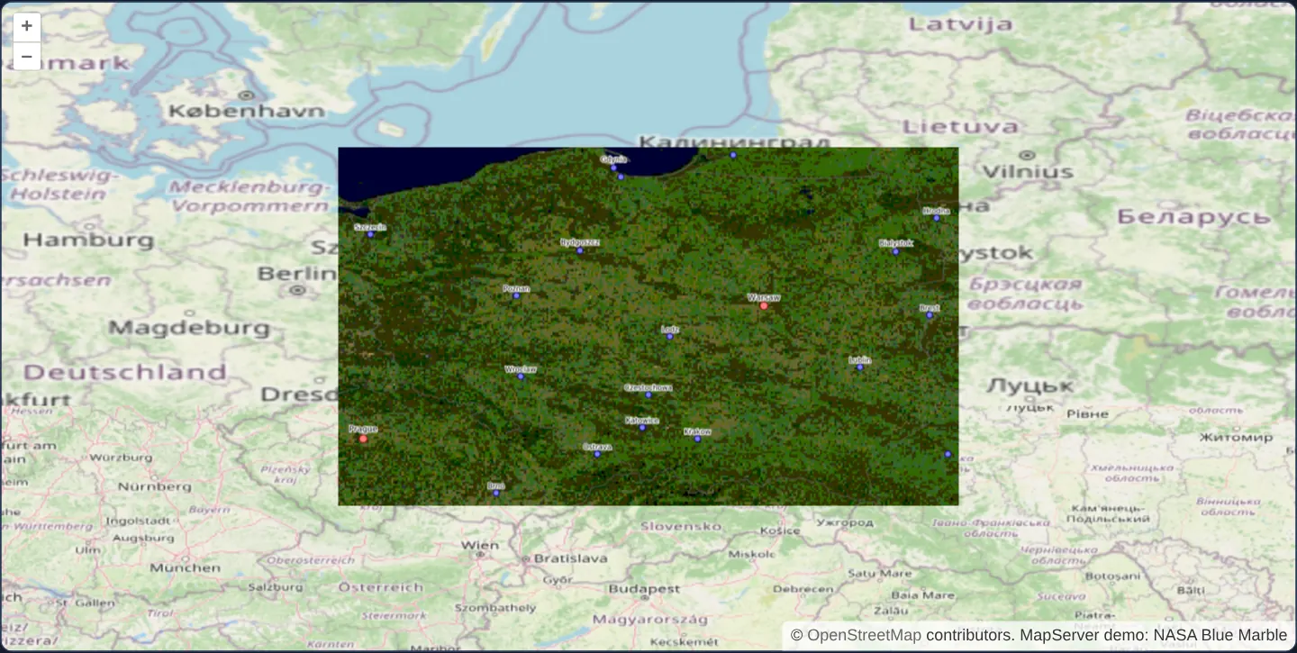
Render legacy native MapServer mode=map CGI layers in geographic EPSG:4326 degrees over reprojected OpenStreetMap tiles within Poland bounds.
What this example shows
Framed over Poland at zoom 6 in geographic EPSG:4326 degrees, MapServer’s native non-WMS CGI endpoint (mode=map) draws Blue Marble land imagery, borders and major cities inside Poland’s bounding box over a client-reprojected OpenStreetMap backdrop.
When you need it
Long-lived government and academic intranet systems occasionally expose older .map configurations exclusively through MapServer’s classic CGI query parameters (mode=map&mapext=...&layers=...) without OGC WMS wrappers enabled.
OpenLayers’ dedicated MapServer loader integrates those legacy endpoints cleanly alongside modern XYZ or vector layers during incremental migrations.
The code
The example uses cc-openlayers, my Angular component library for OpenLayers: each aol-… element creates the OpenLayers object it names, updates it from its inputs and disposes of it with the component.
mapserver-cgi.tsimport { ChangeDetectionStrategy, Component } from '@angular/core';
import {
DefaultControlComponent,
DefaultInteractionComponent,
LayerImageComponent,
LayerTileComponent,
MapComponent,
SourceImageComponent,
SourceOsmComponent,
ViewComponent,
} from 'cc-openlayers';
import { getCenter } from 'ol/extent';
import { createLoader } from 'ol/source/mapserver';
const mapserverUrl = 'https://demo.mapserver.org/cgi-bin/wms?';
/** Poland's bounding box, in the degrees of the demo's map file and of the view. */
const bounds = [14.07, 49.0, 24.15, 54.84];
/**
* An image of MapServer's CGI interface (`mode=map`), not of its WMS: the demo's world map file draws Blue Marble,
* country borders and cities for the map's extent, and the layer's extent keeps the image within Poland's bounding
* box, over OpenStreetMap reprojected into the view's degrees.
*/
@Component({
selector: 'app-mapserver-cgi',
imports: [
DefaultControlComponent,
DefaultInteractionComponent,
LayerImageComponent,
LayerTileComponent,
MapComponent,
SourceImageComponent,
SourceOsmComponent,
ViewComponent,
],
changeDetection: ChangeDetectionStrategy.OnPush,
template: `
<aol-map height="480px">
<aol-interaction-default />
<aol-control-defaults />
<aol-view projection="EPSG:4326" [center]="center" [zoom]="6" />
<aol-layer-tile><aol-source-osm /></aol-layer-tile>
<aol-layer-image [extent]="bounds">
<aol-source-image [loader]="loader" attributions="MapServer demo: NASA Blue Marble" />
</aol-layer-image>
</aol-map>
`,
})
export class MapserverCgi {
protected readonly bounds = bounds;
protected readonly center = getCenter(bounds);
protected readonly loader = createLoader({
url: mapserverUrl,
params: { layers: 'bluemarble country_bounds cities' },
});
} The React version uses the library's React adapter, cc-openlayers/react: each component creates the OpenLayers object it names when it mounts, updates it from its props and disposes of it when it unmounts.
mapserver-cgi.react.tsximport {
DefaultControls,
DefaultInteractions,
ImageLayer,
ImageSource,
Map,
OSMSource,
TileLayer,
View,
} from 'cc-openlayers/react';
import { getCenter } from 'ol/extent.js';
import { createLoader } from 'ol/source/mapserver.js';
const mapserverUrl = 'https://demo.mapserver.org/cgi-bin/wms?';
/** Poland's bounding box, in the degrees of the demo's map file and of the view. */
const bounds = [14.07, 49.0, 24.15, 54.84];
const center = getCenter(bounds);
const loader = createLoader({
url: mapserverUrl,
params: { layers: 'bluemarble country_bounds cities' },
});
/**
* An image of MapServer's CGI interface (`mode=map`), not of its WMS: the demo's world map file draws Blue Marble,
* country borders and cities for the map's extent, and the layer's extent keeps the image within Poland's bounding
* box, over OpenStreetMap reprojected into the view's degrees.
*/
export function MapserverCgi() {
return (
<Map height="480px">
<DefaultInteractions />
<DefaultControls />
<View projection="EPSG:4326" center={center} zoom={6} />
<TileLayer>
<OSMSource />
</TileLayer>
<ImageLayer extent={bounds}>
<ImageSource loader={loader} attributions="MapServer demo: NASA Blue Marble" />
</ImageLayer>
</Map>
);
}How the React version works
An image from MapServer's CGI interface (mode=map), not its WMS, limited to a rectangle around Poland over OpenStreetMap in degrees.
What both versions share
OpenLayers renders the map and handles the interactions; the cc-openlayers/core layer gives both adapters the same view binding (MapViewBinding) and the same conversion of coordinates from EPSG:4326 to the map's projection. The loading function from createLoader (ol/source/mapserver) is created once.
From Angular to React
| Angular | React |
|---|---|
<aol-source-image [loader]> | <ImageSource loader={loader}> |
Who creates, updates and disposes
Map creates the ol/Map in useLayoutEffect and disposes of it on unmount; each layer, source and interaction component adds its object to the parent it gets from context and removes it in its effect's cleanup, as ngOnDestroy does in Angular.
Architecture and OpenLayers mechanics
createLoader from OpenLayers’ MapServer module builds mode=map requests passing space-delimited layers, pixel image size and map extent—relying on the .map file’s native degree coordinate system without a WMS CRS parameter.
Layer [extent] restricts CGI requests to bounds (Poland’s degree box, centred initially via getCenter), while aol-source-osm underneath demonstrates OpenLayers automatically warping Web Mercator street tiles into the view’s EPSG:4326 degree projection.
How it works
- OpenLayers’ MapServer
createLoaderspeaks nativemode=mapCGI parameters directly from extent and pixel dimensions. layerslists.maplayer names separated by spaces rather than WMS commas.- Because CGI
mode=mapuses the server mapfile’s native degree CRS, the OpenLayers view runs in matching degrees. - Layer
[extent]fences requests tobounds(centred viagetCenter), whileaol-source-osmreprojects Web Mercator tiles into degrees underneath.
Pitfalls
- Prefer standard OGC WMS (mapserver-wms) whenever you control server configuration—native CGI
mode=maplacks standardised capabilities discovery, GetFeatureInfo and projection negotiation. - Unlike WMS with serverType mapserver, the CGI loader requests Retina pixel counts without passing MAP_RESOLUTION, causing server-drawn point symbols and text to appear smaller on 2x displays.
Related examples
The same feature in the OpenLayers examples .
Background: state and lifecycle of maps in Angular with OpenLayers, which the components of cc-openlayers take care of.