Layers · Angular, React and OpenLayers
Switch layers by resolution
Control scale-dependent OpenLayers tile layers in map units per pixel using inclusive minResolution and exclusive maxResolution thresholds.
What this example shows
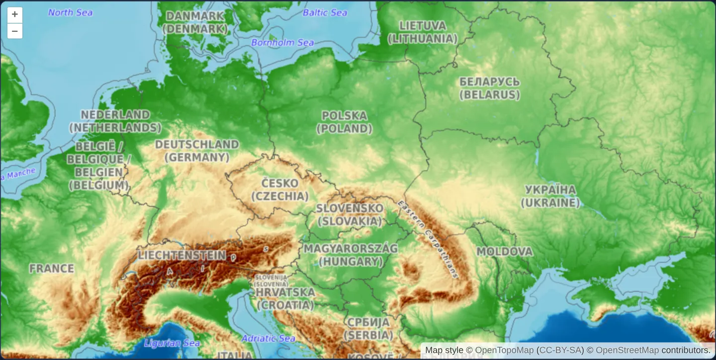
Opening at zoom 5 across central Europe from the Baltic Sea to the Carpathians and Alps, the map displays OpenTopoMap’s regional shaded contours. Zooming in past ~zoom 6.3 switches automatically to OpenStreetMap street tiles for zooms 7 through 9, while zooming out to zoom 2 or zooming in to 10+ leaves both layers outside their resolution bands.
When you need it
Cartographic styling rules, OGC SLD/WMS MinScaleDenominator specifications and custom local-projection GIS projects frequently define visibility windows in ground/map units per pixel rather than Web Mercator tile zoom integers.
Using minResolution and maxResolution keeps visibility thresholds anchored directly to physical map resolution even when views use custom tile grids or continuous fractional zooms.
The code
The example uses cc-openlayers, my Angular component library for OpenLayers: each aol-… element creates the OpenLayers object it names, updates it from its inputs and disposes of it with the component.
min-max-resolution.tsimport { ChangeDetectionStrategy, Component } from '@angular/core';
import { ATTRIBUTION } from 'ol/source/OSM';
import {
CoordinateComponent,
DefaultControlComponent,
DefaultInteractionComponent,
LayerTileComponent,
MapComponent,
SourceOsmComponent,
SourceXYZComponent,
ViewComponent,
} from 'cc-openlayers';
/** A topographic map at small scales and the street map at middle ones, each shown only within its resolutions. */
@Component({
selector: 'app-min-max-resolution',
imports: [
CoordinateComponent,
DefaultControlComponent,
DefaultInteractionComponent,
LayerTileComponent,
MapComponent,
SourceOsmComponent,
SourceXYZComponent,
ViewComponent,
],
changeDetection: ChangeDetectionStrategy.OnPush,
template: `
<aol-map height="480px">
<aol-interaction-default />
<aol-control-defaults />
<aol-view [zoom]="5">
<aol-coordinate [x]="19.9368" [y]="50.0614" srid="EPSG:4326" />
</aol-view>
<aol-layer-tile [minResolution]="200" [maxResolution]="2000"><aol-source-osm /></aol-layer-tile>
<aol-layer-tile [minResolution]="2000" [maxResolution]="20000">
<aol-source-xyz
url="https://tile.opentopomap.org/{z}/{x}/{y}.png"
[maxZoom]="17"
[attributions]="topoAttributions"
/>
</aol-layer-tile>
</aol-map>
`,
})
export class MinMaxResolution {
protected readonly topoAttributions = [
'Map style © <a href="https://opentopomap.org/">OpenTopoMap</a> (<a href="https://creativecommons.org/licenses/by-sa/3.0/">CC-BY-SA</a>)',
ATTRIBUTION,
];
} The React version uses the library's React adapter, cc-openlayers/react: each component creates the OpenLayers object it names when it mounts, updates it from its props and disposes of it when it unmounts.
min-max-resolution.react.tsximport { ATTRIBUTION } from 'ol/source/OSM.js';
import {
Coordinate,
DefaultControls,
DefaultInteractions,
Map,
OSMSource,
TileLayer,
View,
XYZSource,
} from 'cc-openlayers/react';
const topoAttributions = [
'Map style © <a href="https://opentopomap.org/">OpenTopoMap</a> (<a href="https://creativecommons.org/licenses/by-sa/3.0/">CC-BY-SA</a>)',
ATTRIBUTION,
];
/** A topographic map at small scales and the street map at middle ones, each shown only within its resolutions. */
export function MinMaxResolution() {
return (
<Map height="480px">
<DefaultInteractions />
<DefaultControls />
<View zoom={5}>
<Coordinate x={19.9368} y={50.0614} srid="EPSG:4326" />
</View>
<TileLayer minResolution={200} maxResolution={2000}>
<OSMSource />
</TileLayer>
<TileLayer minResolution={2000} maxResolution={20000}>
<XYZSource url="https://tile.opentopomap.org/{z}/{x}/{y}.png" maxZoom={17} attributions={topoAttributions} />
</TileLayer>
</Map>
);
}How the React version works
The topographic map shows from 2,000 to 20,000 m per pixel and the street map from 200 to 2,000. Zooming in, one replaces the other.
What both versions share
OpenLayers renders the map and handles the interactions; the cc-openlayers/core layer gives both adapters the same view binding (MapViewBinding) and the same conversion of coordinates from EPSG:4326 to the map's projection.
From Angular to React
| Angular | React |
|---|---|
[minResolution], [maxResolution] | minResolution, maxResolution |
<aol-source-xyz [attributions]> | <XYZSource attributions={topoAttributions}> with a module constant |
Who creates, updates and disposes
Map creates the ol/Map in useLayoutEffect and disposes of it on unmount; each layer, source and interaction component adds its object to the parent it gets from context and removes it in its effect's cleanup, as ngOnDestroy does in Angular.
Architecture and OpenLayers mechanics
Each aol-layer-tile declares [minResolution] and [maxResolution] in the view’s coordinate units per CSS pixel: OpenTopoMap spans 2000 to 20000 m/px, and OpenStreetMap spans 200 to 2000 m/px. Mirroring zoom limits, OpenLayers includes the detailed boundary (resolution >= minResolution) and excludes the coarse boundary (resolution < maxResolution).
Because Web Mercator resolution 2000 falls at fractional zoom ~6.29, integer zooms 3–6 render OpenTopoMap (configured via aol-source-xyz with source [maxZoom] 17) and integer zooms 7–9 render OpenStreetMap.
How it works
[minResolution](inclusive) and[maxResolution](exclusive) define eachaol-layer-tilevisibility band in map units per pixel.- A threshold of 2000 Web Mercator units per pixel corresponds to zoom ~6.29, showing OpenTopoMap on integer zooms 3–6 and OpenStreetMap on zooms 7–9.
- OpenTopoMap streams through
aol-source-xyzwith its required attribution and native source[maxZoom]of 17.
Pitfalls
- Resolution values are measured in projection units rather than true ground metres: at Kraków’s 50° N latitude, one Web Mercator unit equals roughly 0.64 ground metres, so
200map units per pixel represents ~128 metres on the ground. - Keep boundary inclusivity straight: a layer renders at exact
minResolution(most detailed end) and turns off at exactmaxResolution(coarsest end), so sharing2000across two adjacent layers hands off cleanly without overlap.
Related examples
The same feature in the OpenLayers examples .
Background: state and lifecycle of maps in Angular with OpenLayers, which the components of cc-openlayers take care of.