Layers · Angular, React and OpenLayers
An SVG map as a layer
Mount an interactive SVG map of Poland’s voivodeships as a custom OpenLayers render layer aligned via composeCssTransform and styled with CSS.
What this example shows
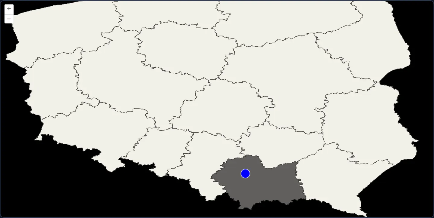
Against a dark backdrop, a crisp vector SVG drawing of Poland’s 16 voivodeships with a marker on Kraków pans, zooms and rotates smoothly as an OpenLayers map layer.
Moving the pointer across regional boundaries highlights each voivodeship directly through native CSS :hover rules on <path> elements—without writing JavaScript hit-detection loops.
When you need it
Architectural floorplans, schematic transit diagrams, custom data visualisations and pre-authored Illustrator/Inkscape SVGs often carry rich CSS classes, gradients, filters and DOM hover states of their own.
Mounting an existing SVG DOM subtree directly as a custom render layer preserves native SVG DOM events and CSS :hover styling while delegating pan, zoom and rotation math to OpenLayers.
The code
The example uses cc-openlayers, my Angular component library for OpenLayers: each aol-… element creates the OpenLayers object it names, updates it from its inputs and disposes of it with the component.
svg-layer.css/* As on the OpenLayers page: a black map, and the voivodeship under the pointer fades, as the map's other layers let
the pointer through to the SVG. */
app-svg-layer .ol-viewport {
background: black;
}
app-svg-layer .svg-layer path:hover {
opacity: 0.4;
}
app-svg-layer .ol-layer {
pointer-events: none;
}svg-layer.tsimport { DOCUMENT } from '@angular/common';
import { ChangeDetectionStrategy, Component, PendingTasks, ViewEncapsulation, inject } from '@angular/core';
import type { FrameState } from 'ol/Map';
import { composeCssTransform } from 'ol/transform';
import {
CoordinateComponent,
DefaultControlComponent,
DefaultInteractionComponent,
FeatureComponent,
GeometryPointComponent,
LayerRenderComponent,
LayerVectorComponent,
MapComponent,
SourceVectorComponent,
ViewComponent,
} from 'cc-openlayers';
/** The SVG map's extent in degrees (west, south, east, north) and its size in pixels: tools/make-poland-svg.mjs. */
const SVG_EXTENT = [14, 49, 24.5, 55];
const WIDTH = 2048;
const HEIGHT = 1170;
const SVG_RESOLUTION = (SVG_EXTENT[2] - SVG_EXTENT[0]) / WIDTH;
/**
* An SVG map of Poland's voivodeships as a layer: a layer with a render function returns the SVG for each frame,
* placed for the view by a CSS transform. The voivodeship under the pointer fades through a CSS `:hover` rule
* alone (svg-layer.css); the blue circle on Kraków is a feature of a vector layer over it.
*/
@Component({
selector: 'app-svg-layer',
imports: [
CoordinateComponent,
DefaultControlComponent,
DefaultInteractionComponent,
FeatureComponent,
GeometryPointComponent,
LayerRenderComponent,
LayerVectorComponent,
MapComponent,
SourceVectorComponent,
ViewComponent,
],
changeDetection: ChangeDetectionStrategy.OnPush,
// The rules style elements that OpenLayers and the render function create, outside this component's template.
encapsulation: ViewEncapsulation.None,
styleUrl: './svg-layer.css',
template: `
<aol-map height="480px">
<aol-interaction-default />
<aol-control-defaults />
<aol-view projection="EPSG:4326" [extent]="extent" [zoom]="7">
<aol-coordinate [x]="19.9368" [y]="50.0614" srid="EPSG:4326" />
</aol-view>
<aol-layer-render [render]="render" />
<aol-layer-vector
[style]="{ 'circle-fill-color': '#0000ff', 'circle-radius': 10, 'circle-stroke-color': '#ffffff' }"
>
<aol-source-vector>
<aol-feature>
<aol-geometry-point><aol-coordinate [x]="19.9368" [y]="50.0614" srid="EPSG:4326" /></aol-geometry-point>
</aol-feature>
</aol-source-vector>
</aol-layer-vector>
</aol-map>
`,
})
export class SvgLayer {
protected readonly extent = SVG_EXTENT;
/** The element the layer shows: the SVG map, moved and scaled for each frame. */
private readonly container = inject(DOCUMENT).createElement('div');
constructor() {
Object.assign(this.container.style, {
width: `${WIDTH}px`,
height: `${HEIGHT}px`,
transformOrigin: 'top left',
position: 'absolute',
});
this.container.className = 'svg-layer';
void inject(PendingTasks).run(async () => {
const text = await (await fetch('assets/poland/voivodeships.svg')).text();
const svg = new DOMParser().parseFromString(text, 'image/svg+xml').documentElement;
this.container.appendChild(this.container.ownerDocument.importNode(svg, true));
});
}
/** Puts the SVG pixel of the view's centre in the middle of the map, scaled from the SVG's resolution. */
protected readonly render = (frameState: FrameState): HTMLElement => {
const { center, resolution, rotation } = frameState.viewState;
const scale = SVG_RESOLUTION / resolution;
this.container.style.transform = composeCssTransform(
frameState.size[0] / 2,
frameState.size[1] / 2,
scale,
scale,
rotation,
-(center[0] - SVG_EXTENT[0]) / SVG_RESOLUTION,
(center[1] - SVG_EXTENT[3]) / SVG_RESOLUTION
);
this.container.style.opacity = String(frameState.layerStatesArray[frameState.layerIndex].opacity);
return this.container;
};
} The React version uses the library's React adapter, cc-openlayers/react: each component creates the OpenLayers object it names when it mounts, updates it from its props and disposes of it when it unmounts.
svg-layer.react.tsximport { useEffect, useState } from 'react';
import type { FrameState } from 'ol/Map.js';
import { composeCssTransform } from 'ol/transform.js';
import {
Coordinate,
DefaultControls,
DefaultInteractions,
Feature,
Map,
PointGeometry,
RenderLayer,
VectorLayer,
VectorSource,
View,
} from 'cc-openlayers/react';
/** The SVG map's extent in degrees (west, south, east, north) and its size in pixels: tools/make-poland-svg.mjs. */
const SVG_EXTENT = [14, 49, 24.5, 55];
const WIDTH = 2048;
const HEIGHT = 1170;
const SVG_RESOLUTION = (SVG_EXTENT[2] - SVG_EXTENT[0]) / WIDTH;
const circle = { 'circle-fill-color': '#0000ff', 'circle-radius': 10, 'circle-stroke-color': '#ffffff' };
/*
* The rules of svg-layer.css, scoped to this example's wrapper as the Angular version scopes them to its host element:
* a black map, and the voivodeship under the pointer fades, as the map's other layers let the pointer through to the SVG.
*/
const stylesheet = `
.svg-layer-example .ol-viewport {
background: black;
}
.svg-layer-example .svg-layer path:hover {
opacity: 0.4;
}
.svg-layer-example .ol-layer {
pointer-events: none;
}
`;
/**
* An SVG map of Poland's voivodeships as a layer: a layer with a render function returns the SVG for each frame,
* placed for the view by a CSS transform. The voivodeship under the pointer fades through a CSS `:hover` rule
* alone (svg-layer.css); the blue circle on Kraków is a feature of a vector layer over it.
*/
export function SvgLayer() {
/** The element the layer shows: the SVG map, moved and scaled for each frame. */
const [container] = useState(() => {
const element = document.createElement('div');
Object.assign(element.style, {
width: `${WIDTH}px`,
height: `${HEIGHT}px`,
transformOrigin: 'top left',
position: 'absolute',
});
element.className = 'svg-layer';
return element;
});
useEffect(() => {
let current = true;
void (async () => {
const text = await (await fetch('assets/poland/voivodeships.svg')).text();
if (!current) return;
const svg = new DOMParser().parseFromString(text, 'image/svg+xml').documentElement;
container.replaceChildren(container.ownerDocument.importNode(svg, true));
})();
return () => {
current = false;
};
}, [container]);
/** Puts the SVG pixel of the view's centre in the middle of the map, scaled from the SVG's resolution. */
const [render] = useState(() => (frameState: FrameState): HTMLElement => {
const { center, resolution, rotation } = frameState.viewState;
const scale = SVG_RESOLUTION / resolution;
container.style.transform = composeCssTransform(
frameState.size[0] / 2,
frameState.size[1] / 2,
scale,
scale,
rotation,
-(center[0] - SVG_EXTENT[0]) / SVG_RESOLUTION,
(center[1] - SVG_EXTENT[3]) / SVG_RESOLUTION
);
container.style.opacity = String(frameState.layerStatesArray[frameState.layerIndex].opacity);
return container;
});
return (
<div className="svg-layer-example">
<style>{stylesheet}</style>
<Map height="480px">
<DefaultInteractions />
<DefaultControls />
<View projection="EPSG:4326" extent={SVG_EXTENT} zoom={7}>
<Coordinate x={19.9368} y={50.0614} srid="EPSG:4326" />
</View>
<RenderLayer render={render} />
<VectorLayer style={circle}>
<VectorSource>
<Feature>
<PointGeometry>
<Coordinate x={19.9368} y={50.0614} srid="EPSG:4326" />
</PointGeometry>
</Feature>
</VectorSource>
</VectorLayer>
</Map>
</div>
);
}How the React version works
An SVG map of the voivodeships is a layer: the render function returns the same SVG element in each frame, moved and scaled by a CSS transform. The voivodeship under the cursor fades through a :hover rule alone, and a blue circle on Kraków lies on a vector layer above the SVG.
What both versions share
OpenLayers renders the map and handles the interactions; the cc-openlayers/core layer gives both adapters the same view binding (MapViewBinding) and the same conversion of coordinates from EPSG:4326 to the map's projection. The render function and the SVG's extent and resolution are the same in both versions; the file is assets/poland/voivodeships.svg.
From Angular to React
| Angular | React |
|---|---|
<aol-layer-render [render]="render"> | <RenderLayer render={render} />, the function from a useState initialiser, so it stays the same between renders |
styleUrl: './svg-layer.css' with ViewEncapsulation.None and app-svg-layer … selectors | a <style> element with the same rules under the .svg-layer-example class on the wrapping div: React has no host element, and the example imports no CSS |
a container element created in the constructor, the SVG fetched in PendingTasks.run | the container from a useState initialiser, the fetch in a useEffect with a flag that ignores an answer after unmount |
Who creates, updates and disposes
Map creates the ol/Map in useLayoutEffect and disposes of it on unmount; each layer, source and interaction component adds its object to the parent it gets from context and removes it in its effect's cleanup, as ngOnDestroy does in Angular. Under StrictMode the fetch effect runs twice; the flag cancels the first fetch.
Architecture and OpenLayers mechanics
aol-layer-render builds a sourceless OpenLayers Layer driven by a custom render callback invoked on every animation frame. Because the SVG artwork is authored directly in equirectangular longitude/latitude coordinates (spanning 10.5 degrees across 2048 SVG units) and the map view also runs in EPSG:4326 bounded by [extent], a single affine matrix computed via composeCssTransform translates, scales and rotates the SVG container to match the live view state.
Applying layer state opacity to the wrapper respects parent group fading, while setting pointer-events to none on sibling canvas layers lets mouse hover reach the underlying SVG <path> nodes.
How it works
aol-layer-renderinvokes its customrenderfunction on each frame and mounts the returned SVG container element directly inside the layer stack.composeCssTransformcomputes the exact CSS matrix translating the view centre to the viewport midpoint, scaling from SVG units to view resolution, and applying view rotation.- Matching
EPSG:4326between both the SVG drawing and the OpenLayers view—fenced by[extent]—keeps geographic alignment exact under affine CSS scaling. - Native CSS
:hoverrules fade hovered voivodeship paths whilepointer-eventsnone on other layers lets pointer events reach the SVG DOM.
Pitfalls
- Affine CSS transforms scale uniformly along X and Y: an equirectangular
EPSG:4326SVG will only align over anEPSG:4326view and would stretch vertically north-to-south if placed over a Web Mercator (EPSG:3857) map without pre-projecting the SVG paths. - OpenLayers’ forEachFeatureAtPixel ignores custom DOM/SVG layers—attach click or hover handlers via standard DOM events or Angular/React bindings on the SVG elements themselves.
Related examples
The same feature in the OpenLayers examples .
Background: state and lifecycle of maps in Angular with OpenLayers, which the components of cc-openlayers take care of.