Tile and image services · Angular, React and OpenLayers
WMS tiles of 512 by 256 pixels
Configure a custom 512x256 rectangular OpenLayers TileGrid bounded to Poland for tiled WMS requests and inspect seams with a TileDebug layer.
What this example shows
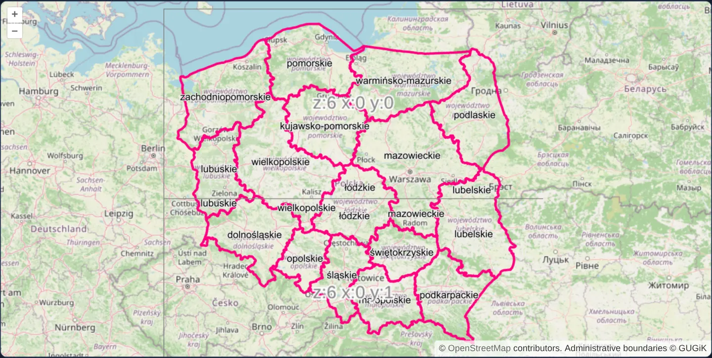
At zoom 6 across Poland, voivodeship boundaries from GUGiK’s WMS load in wide rectangular 512 × 256 pixel tiles anchored to the northwest corner of Poland’s bounding box, while a matching TileDebug wireframe outlines and labels the exact two stacked tiles covering the country.
When you need it
Standard 256 × 256 tiles can generate excessive HTTP request counts across wide widescreen monitors—and standard global WMS grids still evaluate coordinates outside your national dataset.
Because dynamic OGC WMS servers draw arbitrary BBOX and WIDTH/HEIGHT combinations on demand, a custom rectangular TileGrid halves horizontal request counts and restricts grid indexing strictly to your coverage extent.
The code
The example uses cc-openlayers, my Angular component library for OpenLayers: each aol-… element creates the OpenLayers object it names, updates it from its inputs and disposes of it with the component.
wms-custom-tilegrid-512x256.tsimport { ChangeDetectionStrategy, Component } from '@angular/core';
import {
CoordinateComponent,
DefaultControlComponent,
DefaultInteractionComponent,
LayerTileComponent,
MapComponent,
SourceOsmComponent,
SourceTileDebugComponent,
SourceTileWMSComponent,
ViewComponent,
} from 'cc-openlayers';
import { getWidth } from 'ol/extent';
import { get as getProjection } from 'ol/proj';
import type Projection from 'ol/proj/Projection';
import TileGrid from 'ol/tilegrid/TileGrid';
/**
* Poland's voivodeship boundaries requested in 512 by 256 pixel tiles over a tile grid limited to the country, with
* the grid's tiles outlined and numbered above them.
*/
@Component({
selector: 'app-wms-custom-tilegrid-512x256',
imports: [
CoordinateComponent,
DefaultControlComponent,
DefaultInteractionComponent,
LayerTileComponent,
MapComponent,
SourceOsmComponent,
SourceTileDebugComponent,
SourceTileWMSComponent,
ViewComponent,
],
changeDetection: ChangeDetectionStrategy.OnPush,
template: `
<aol-map height="480px">
<aol-interaction-default />
<aol-control-defaults />
<aol-view [zoom]="6"><aol-coordinate [x]="19.4" [y]="52.1" srid="EPSG:4326" /></aol-view>
<aol-layer-tile><aol-source-osm /></aol-layer-tile>
<aol-layer-tile>
<aol-source-tilewms
url="https://mapy.geoportal.gov.pl/wss/service/PZGIK/PRG/WMS/AdministrativeBoundaries"
[params]="{ LAYERS: 'A01_Granice_wojewodztw', TILED: true }"
serverType="mapserver"
[tileGrid]="tileGrid"
attributions="Administrative boundaries © GUGiK"
/>
</aol-layer-tile>
<aol-layer-tile><aol-source-tiledebug [tileGrid]="tileGrid" /></aol-layer-tile>
</aol-map>
`,
})
export class WmsCustomTilegrid512x256 {
protected readonly tileGrid = createTileGrid();
}
/** Resolutions of the Web Mercator world in 256 pixel tiles, an extent around Poland and tiles 512 wide, 256 high. */
function createTileGrid(): TileGrid {
const webMercator = getProjection('EPSG:3857') as Projection;
const startResolution = getWidth(webMercator.getExtent()) / 256;
return new TileGrid({
extent: [1525077, 6207260, 2771855, 7381298],
resolutions: Array.from({ length: 22 }, (_, zoom) => startResolution / Math.pow(2, zoom)),
tileSize: [512, 256],
});
} The React version uses the library's React adapter, cc-openlayers/react: each component creates the OpenLayers object it names when it mounts, updates it from its props and disposes of it when it unmounts.
wms-custom-tilegrid-512x256.react.tsximport {
Coordinate,
DefaultControls,
DefaultInteractions,
Map,
OSMSource,
TileDebugSource,
TileLayer,
TileWMSSource,
View,
} from 'cc-openlayers/react';
import { getWidth } from 'ol/extent.js';
import { get as getProjection } from 'ol/proj.js';
import type Projection from 'ol/proj/Projection.js';
import TileGrid from 'ol/tilegrid/TileGrid.js';
/** Resolutions of the Web Mercator world in 256 pixel tiles, an extent around Poland and tiles 512 wide, 256 high. */
function createTileGrid(): TileGrid {
const webMercator = getProjection('EPSG:3857') as Projection;
const startResolution = getWidth(webMercator.getExtent()) / 256;
return new TileGrid({
extent: [1525077, 6207260, 2771855, 7381298],
resolutions: Array.from({ length: 22 }, (_, zoom) => startResolution / Math.pow(2, zoom)),
tileSize: [512, 256],
});
}
const tileGrid = createTileGrid();
const params = { LAYERS: 'A01_Granice_wojewodztw', TILED: true };
/**
* Poland's voivodeship boundaries requested in 512 by 256 pixel tiles over a tile grid limited to the country, with
* the grid's tiles outlined and numbered above them.
*/
export function WmsCustomTilegrid512x256() {
return (
<Map height="480px">
<DefaultInteractions />
<DefaultControls />
<View zoom={6}>
<Coordinate x={19.4} y={52.1} srid="EPSG:4326" />
</View>
<TileLayer>
<OSMSource />
</TileLayer>
<TileLayer>
<TileWMSSource
url="https://mapy.geoportal.gov.pl/wss/service/PZGIK/PRG/WMS/AdministrativeBoundaries"
params={params}
serverType="mapserver"
tileGrid={tileGrid}
attributions="Administrative boundaries © GUGiK"
/>
</TileLayer>
<TileLayer>
<TileDebugSource tileGrid={tileGrid} />
</TileLayer>
</Map>
);
}How the React version works
Voivodeship borders fetched in 512 by 256 pixel tiles on a grid limited to Poland, with the grid labelled by a debug layer.
What both versions share
OpenLayers renders the map and handles the interactions; the cc-openlayers/core layer gives both adapters the same view binding (MapViewBinding) and the same conversion of coordinates from EPSG:4326 to the map's projection. The tile grid is created once, when the module loads, and serves both sources.
From Angular to React
| Angular | React |
|---|---|
<aol-source-tilewms [tileGrid]>, <aol-source-tiledebug [tileGrid]> | <TileWMSSource tileGrid>, <TileDebugSource tileGrid> |
Who creates, updates and disposes
Map creates the ol/Map in useLayoutEffect and disposes of it on unmount; each layer, source and interaction component adds its object to the parent it gets from context and removes it in its effect's cleanup, as ngOnDestroy does in Angular.
Architecture and OpenLayers mechanics
An explicit OpenLayers TileGrid specifies tileSize: [512, 256], Poland’s projected Web Mercator extent, and 22 resolution steps. With no separate origin passed, tile indexing starts cleanly at the top-left (northwest) corner of Poland’s extent.
Passing [tileGrid] both to aol-source-tilewms and to a companion aol-source-tiledebug layer lets you verify the exact rectangular cell boundaries—including how provinces straddling the horizontal seam (such as mazowieckie and łódzkie) receive labels in both tiles.
How it works
TileGriddefines rectangulartileSize: [512, 256]cells across Poland’s extent and 22 Web Mercator resolution levels.- Omitting a custom origin anchors tile (0, 0) at the northwest corner of Poland’s bounding box.
[tileGrid]drives aol-source-tilewms to request 512 × 256 GetMap images strictly inside Poland.- Sharing the identical
[tileGrid]withaol-source-tiledebugvisualises tile seams and indices directly over the boundaries.
Pitfalls
- Custom non-square grids anchored to a local extent will not match pre-seeded global 256 × 256 XYZ/WMTS caches—use them only against dynamic WMS endpoints or caches seeded with the identical grid.
- Remember HiDPI multiplication against server MaxWidth / MaxHeight limits in GetCapabilities: on a 2x Retina screen, a 512 × 256 logical tile requests 1024 × 512 pixels, which can exceed a stricter server’s MaxWidth / MaxHeight.
- Independent per-tile labelling names polygons crossed by a tile seam once in each tile.
Related examples
The same feature in the OpenLayers examples .
Background: state and lifecycle of maps in Angular with OpenLayers, which the components of cc-openlayers take care of.