Vector data · Angular, React and OpenLayers
Place markers along a route
Measure geographic route length and place distance-interval markers along polylines in OpenLayers using @turf/length and @turf/along helpers.
What this example shows
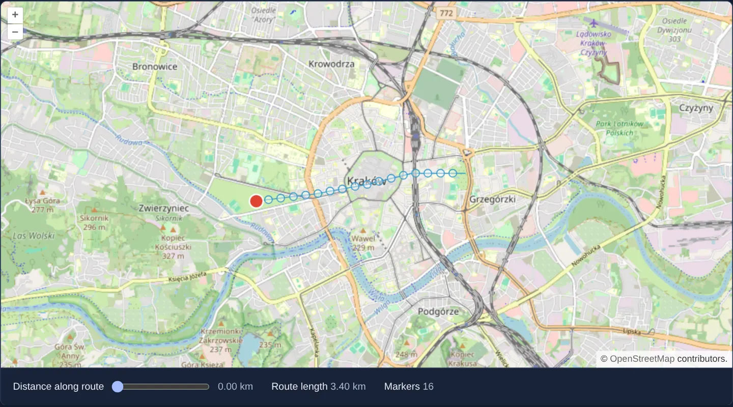
Along a route over Kraków on OpenStreetMap, geographic chainage markers (km posts / distance intervals) are positioned accurately along the path and linked to an interactive distance control shared across Angular and React.
When you need it
Highway linear referencing (kilometre posts), pipeline inspection stationing, marathon mile markers and hiking-trail elevation callouts all place points at exact geodesic distances measured along a route.
Combining Turf’s modular geodesic helpers (@turf/length and @turf/along) with OpenLayers vector features keeps bundle size minimal and distance math accurate.
The code
The example uses cc-openlayers, my Angular component library for OpenLayers: each aol-… element creates the OpenLayers object it names, updates it from its inputs and disposes of it with the component.
turf.html<aol-map height="480px"
><aol-control-defaults /><aol-interaction-default /><aol-view [zoom]="13" [maxZoom]="19"
><aol-coordinate [x]="19.9368" [y]="50.0614" srid="EPSG:4326" /></aol-view
><aol-layer-tile><aol-source-osm /></aol-layer-tile
></aol-map>
<div class="example-controls">
<label
>Distance along route
<input type="range" min="0" [max]="length" step="0.01" [value]="distance()" (input)="setDistance($event)" /><output
>{{ distance().toFixed(2) }} km</output
></label
><span
>Route length <output>{{ length.toFixed(2) }} km</output></span
><span
>Markers <output>{{ markerCount }}</output></span
>
</div>turf.shared.tsimport { along } from '@turf/along';
import { length } from '@turf/length';
import Feature from 'ol/Feature';
import GeoJSON from 'ol/format/GeoJSON';
import Point from 'ol/geom/Point';
import VectorSource from 'ol/source/Vector';
import { fromLonLat } from 'ol/proj';
export const ROUTE = [
[19.912, 50.059],
[19.925, 50.06],
[19.937, 50.0614],
[19.947, 50.063],
[19.959, 50.063],
];
const format = new GeoJSON();
function line(coordinates: number[][]) {
return { type: 'Feature' as const, properties: {}, geometry: { type: 'LineString' as const, coordinates } };
}
export function routeLength(coordinates: number[][]): number {
return length(line(coordinates), { units: 'kilometers' });
}
export function routePoint(coordinates: number[][], distance: number): Feature<Point> {
return new Feature(
new Point(fromLonLat(along(line(coordinates), distance, { units: 'kilometers' }).geometry.coordinates))
);
}
export function routeMarkers(coordinates: number[][]): VectorSource {
const features = [format.readFeature(line(coordinates), { featureProjection: 'EPSG:3857' }) as Feature];
for (let distance = 0.2; distance <= routeLength(coordinates); distance += 0.2)
features.push(routePoint(coordinates, distance));
return new VectorSource({ features });
}turf.tsimport { AfterViewInit, ChangeDetectionStrategy, Component, OnDestroy, signal, viewChild } from '@angular/core';
import {
MapComponent,
ViewComponent,
CoordinateComponent,
LayerTileComponent,
SourceOsmComponent,
DefaultControlComponent,
DefaultInteractionComponent,
} from 'cc-openlayers';
import VectorLayer from 'ol/layer/Vector';
import VectorSource from 'ol/source/Vector';
import Style from 'ol/style/Style';
import Circle from 'ol/style/Circle';
import Fill from 'ol/style/Fill';
import Stroke from 'ol/style/Stroke';
import { ROUTE, routeLength, routeMarkers, routePoint } from './turf.shared';
@Component({
selector: 'app-turf',
imports: [
MapComponent,
ViewComponent,
CoordinateComponent,
LayerTileComponent,
SourceOsmComponent,
DefaultControlComponent,
DefaultInteractionComponent,
],
changeDetection: ChangeDetectionStrategy.OnPush,
templateUrl: './turf.html',
})
export class Turf implements AfterViewInit, OnDestroy {
private readonly map = viewChild.required(MapComponent);
readonly length = routeLength(ROUTE);
readonly distance = signal(0);
private readonly source = routeMarkers(ROUTE);
readonly markerCount = this.source.getFeatures().length - 1;
private readonly marker = routePoint(ROUTE, 0);
private cleanup = () => {};
ngAfterViewInit(): void {
const map = this.map().instance,
layers = [
new VectorLayer({ source: this.source }),
new VectorLayer({
source: new VectorSource({ features: [this.marker] }),
style: new Style({
image: new Circle({
radius: 9,
fill: new Fill({ color: '#d43' }),
stroke: new Stroke({ color: '#fff', width: 2 }),
}),
}),
}),
];
layers.forEach((l) => map.addLayer(l));
this.cleanup = () => layers.forEach((l) => map.removeLayer(l));
}
ngOnDestroy(): void {
this.cleanup();
}
setDistance(e: Event): void {
this.distance.set((e.target as HTMLInputElement).valueAsNumber);
this.marker.setGeometry(routePoint(ROUTE, this.distance()).getGeometry());
}
} The React version uses the library's React adapter, cc-openlayers/react: each component creates the OpenLayers object it names when it mounts, updates it from its props and disposes of it when it unmounts.
turf.react.tsximport { useEffect, useState } from 'react';
import { Map, View, Coordinate, TileLayer, OSMSource, DefaultControls, DefaultInteractions } from 'cc-openlayers/react';
import type OLMap from 'ol/Map';
import VectorLayer from 'ol/layer/Vector';
import VectorSource from 'ol/source/Vector';
import Style from 'ol/style/Style';
import Circle from 'ol/style/Circle';
import Fill from 'ol/style/Fill';
import Stroke from 'ol/style/Stroke';
import { ROUTE, routeLength, routeMarkers, routePoint } from './turf.shared';
export function Turf() {
const [map, setMap] = useState<OLMap | null>(null);
const [source] = useState(() => routeMarkers(ROUTE));
const [marker] = useState(() => routePoint(ROUTE, 0));
const [distance, setDistance] = useState(0);
const length = routeLength(ROUTE);
useEffect(() => {
if (!map) return;
const layers = [
new VectorLayer({ source }),
new VectorLayer({
source: new VectorSource({ features: [marker] }),
style: new Style({
image: new Circle({
radius: 9,
fill: new Fill({ color: '#d43' }),
stroke: new Stroke({ color: '#fff', width: 2 }),
}),
}),
}),
];
layers.forEach((l) => map.addLayer(l));
return () => layers.forEach((l) => map.removeLayer(l));
}, [map, source, marker]);
return (
<>
<Map ref={setMap} height="480px">
<DefaultControls />
<DefaultInteractions />
<View zoom={13} maxZoom={19}>
<Coordinate x={19.9368} y={50.0614} srid="EPSG:4326" />
</View>
<TileLayer>
<OSMSource />
</TileLayer>
</Map>
<div className="example-controls">
<label>
Distance along route{' '}
<input
type="range"
min="0"
max={length}
step="0.01"
value={distance}
onChange={(e) => {
const value = e.currentTarget.valueAsNumber;
setDistance(value);
marker.setGeometry(routePoint(ROUTE, value).getGeometry());
}}
/>
<output>{distance.toFixed(2)} km</output>
</label>
<span>
Route length <output>{length.toFixed(2)} km</output>
</span>
<span>
Markers <output>{source.getFeatures().length - 1}</output>
</span>
</div>
</>
);
}turf.shared.tsimport { along } from '@turf/along';
import { length } from '@turf/length';
import Feature from 'ol/Feature';
import GeoJSON from 'ol/format/GeoJSON';
import Point from 'ol/geom/Point';
import VectorSource from 'ol/source/Vector';
import { fromLonLat } from 'ol/proj';
export const ROUTE = [
[19.912, 50.059],
[19.925, 50.06],
[19.937, 50.0614],
[19.947, 50.063],
[19.959, 50.063],
];
const format = new GeoJSON();
function line(coordinates: number[][]) {
return { type: 'Feature' as const, properties: {}, geometry: { type: 'LineString' as const, coordinates } };
}
export function routeLength(coordinates: number[][]): number {
return length(line(coordinates), { units: 'kilometers' });
}
export function routePoint(coordinates: number[][], distance: number): Feature<Point> {
return new Feature(
new Point(fromLonLat(along(line(coordinates), distance, { units: 'kilometers' }).geometry.coordinates))
);
}
export function routeMarkers(coordinates: number[][]): VectorSource {
const features = [format.readFeature(line(coordinates), { featureProjection: 'EPSG:3857' }) as Feature];
for (let distance = 0.2; distance <= routeLength(coordinates); distance += 0.2)
features.push(routePoint(coordinates, distance));
return new VectorSource({ features });
}How the React version works
Measure a route and place points at distances along it using Turf.
What both versions share
@turf/length measures the geographic line and @turf/along locates points along it.
From Angular to React
| Angular | React |
|---|---|
| A signal supplies the selected distance to the shared point calculation. | useState supplies the distance selected by the range input. |
| An external Angular template declares the example. | JSX declares the example and its controls. |
| The Angular lifecycle releases the mounted resources. | Effect or subscription cleanup releases the mounted resources. |
Who creates, updates and disposes
Both versions share the geographic route, its length and the distance markers. The selected point moves without rebuilding the map.
Architecture and OpenLayers mechanics
Shared calculation logic takes the route’s RFC 7946 WGS 84 [longitude, latitude] coordinates directly, computes total geodesic route length with @turf/length, interpolates a highlighted marker along the route with @turf/along as the distance control changes, and projects that marker to EPSG:3857 with fromLonLat, while fixed markers sit every 0.2 km along the line on a second vector layer.
How it works
- Modular helpers @turf/length and @turf/along compute geodesic route length and interpolate marker positions at exact distances along the line.
Pitfalls
- Turf.js functions strictly assume WGS 84 [longitude, latitude] degree coordinates and explicit unit options (
kilometers,meters)—passing rawEPSG:3857Web Mercator metres directly into Turf produces nonsensical planetary distances.
Related examples
The same feature in the OpenLayers examples .
Background: state and lifecycle of maps in Angular with OpenLayers, which the components of cc-openlayers take care of.